Unique Utah!
Here I am, back with yet another post on travel. Utah it is, this time. After reading the Utah travel guide back-to-back, making endless phone calls to the travel offices there inquiring about the weather, what-to-see and what-to-skip, we got ready to travel back in time. Yes, it did feel like a peek into the past.
The road-trip Google map - four days, about 1000miles pickup-to-return.
Rough itinerary:
day 0: fly to salt lake city
day 1: visit salt lake and drive to Bryce, spend the rest of the evening at the canyon
day 2: hike@Bryce, drive to Moab via Goblin Valley State Park
day 3: Arches park, dinosaur track sites
day 4: visit dinosaur museum, tulip gardens at thanksgiving point, and head back home.
There's something unique about Utah. It gets the highest snow on Earth (atleast thats what I was told), houses the most amazing rock formations, once walked across by dinosaurs. Its visitors definitely outnumber the state population. Utah got me interested in reading about Earth's history.
As always, I started off with an ambitiously prepared todo list. In four days, we were able to cover everything but the little sahara recreation area. Really wanted to see sand dunes, may be in Rajasthan (India) some time. Utah has got 5 national parks, and plenty of state parks. Bryce and Arches were the main reasons to travel Utah. Problem is, there's just one main airport, Salt Lake City, and the sight-seeing places are spread all over the state. We decided to just be happy with south-central Utah. See the map for details. Finding a motel was never hard for us. You can either camp at these parks or stay at one of the hotels at driving distance from them. And food, well, there's subway almost everywhere. If you stock up on enough water, about 1 gallon per person per day, you're good to go. If you want to see both Bryce and Arches, I'd suggest you visit in the shoulder months. We were there in April, Bryce was still a little white in the canyon, and totally covered in snow on the mountains. Arches, on the other hand, had temperatures above 80F and left us tanned.
As the map indicates, our trip started from SLC. The drive to Bryce wasn't much exciting, long roads to nowhere with very small towns enroute. Got to see the countryside of America. The first view of Bryce was mindblowing. Sharp needle like structures rising high above the ground beautifully painted in reds highlighted by Sunset effects. Awesome! Looked like a forest of stone to me. Bryce canyon, is actually quite a small section of the total nat park. Its the only interesting portion of the park though. So, when in Bryce, plan to spend most of your time at the first four view points - Sunset, Sunrise, Bryce and Inspiration points. You can just drive through the remainder of the park with a stopover at the natural bridge view point. Also, no matter how long you spend at each of these four view points, unless you hike into the canyon, you would not see Bryce at all. There's this simple trail called Navajo loop that can be done in about 2-3hrs at a moderate walking speed. Its best to do it before noon. Though I cribbed a little bit about the steep hike, I was totally totally satisfied after doing the whole loop. There are some really amazing structures that cannot be seen from the rim. Some sections of the trail could be a little wet from the snow melt if you visit in non-summer months. So, carry plenty of socks and its better you have waterproof boots. Don't need snow boots and all, but something a little waterproof would really help your feet. Also, sunscreen and hats are a must, and not to forget the spare camera batteries.


From Bryce canyon national park, we left for Goblin valley state park. Its this really small park on the way from Bryce to Arches. People say its what Mars looks like. I dont know about that, but it was a different experience walking around the park. You wont need more than an hour here.

Moab - the town next to Arches national park. Plenty of hotels/motels, lots of restaurants, famous for mountain-biking and rock-climbing. Arches national park is actually very very huge, and all but one or two arches can be seen from the road-side. So, be prepared to walk atleast 2-3 miles if you plan to see atleast 6 arches here. There are no eating places inside the park. Rather than going to moab for lunch, its a good idea to pack food so that you can spend the whole day inside the park. Also, fill up your gas tank as you'd be driving a lot. Before visiting I thought there'll be 100s of arches. But no, about 10-12 see-through arches in total, and plenty of them in the making, may be our great-grandchildren would be able to see some more. Its so amazing to see the different stages of arch formations in the park. You can see just the outlines for some, a little depth from erosion for few other arches, and some full-blown arches. My favorite ones are the landscape arch and the delicate arch. The delicate arch, Utah's state symbol stands majestically on the hilltop. Its so silent over there, everything around feels so insignificant next to the delicate arch. Looks as though someone just planted an arch on the hill, doesnt really look like a natural thing. The landscape arch is beautiful for its length. Unfortunately, its breakage started. A decade ago, part of it fell off. It could potentially become a broken arch in several years to come. I wish the delicate arch remains eternal. Actually, looking back, I think there's something else that interested me more than the arches. At the park entrance, there's this view point called "Moab fault" - thats where the land split ages ago from an earthquake. The roads lie down below, flanked by two complementary mountains on either side - terrific view! Besides the arches. there are these broken walls of stone everywhere in the park, called courthouse towers. Quite aptly named as they reminded me of fort walls I've seen back in India. Visit to Arches national park is like visit to an old civilization.


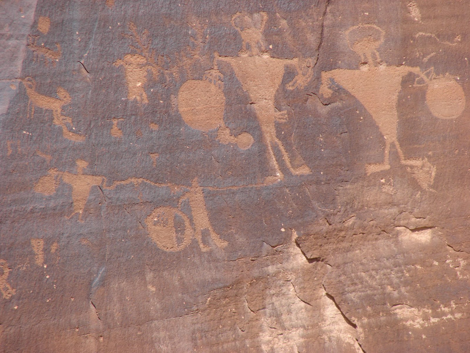
During this visit to Utah, I desperately wanted to see the dinosaur tracks. Heard there are plenty in the Moab area. We did visit two sites - one on the Potash road, and one somewhere in between Moab and Green river. Let me tell you, the Potash road site is just a waste of time. There are one or two tracks on a slab and this slab has been mounted on a hill, requires about 15min of rock climbing to get there. I expected to see something on the ground level, to get a feel of the land the dinosaurs once roamed. This slab looks like what we see in museums. My advice, ditch the idea of driving to Potash road if you're only going to see the tracks. However, there are these cave paintings kind of stone art along the road. Basically, there are these beautiful really really tall cliffs on which you can spot those figures used by the ancient people for communication or whatever.. Not to miss that while in the area. Coming to the other track site, I think its called "Sauropad track site", atleast that was what the Moab visitor center guy excitedly talked to me about. We got there by twilight. I think there are tracks, 'coz we could see some sign boards and all. But we weren't lucky to spot even one - a. it was getting dark, and b. there was no-one else but us, so I was a little adamant about going back to the car asap. You do have to walk about 1000feet uphill to get there.
Day 4 we started our drive back to Salt Lake City. First stop on the way was at the College of Eastern Utah prehistoric museum. A small museum, but well worth the 1 hour we spent there. Cleveland Lloyd dinosaur query was on my itinerary for a while, but since it was a little off the way, I decided to do the museum instead. Whats interesting about the quarry is, at the quarry site, millions of years ago, there was this marshland where dinosaurs would come to drink water and would get stuck in the mud, and eventually become fossilized. So plenty of dinosaur bones et all here. Nevertheless, the museum had some decent exhibits on prehistoric life. Dinosaur tracks, fossilized leaves, dino skeletons etc. Actually, if you're really into dinosaur stuff, you should be touring the "dinosaur diamond" area near the Utah-Colorado border.
From the museum we took off to the tulip garden at the Thanksgiving Point. I thought there would be tulip fields like those in Netherlands, Washington (state). Silly me, when the state (Utah) was so dry, how could I imagine flower fields here. Anyways, there's this nice park here. At this time of the year, they plant tulips across all the walkways in the park. Its good, but not great. If you have a little extra time, definitely stop by. Back in SLC, we just had 30 "extra" minutes left before we checked-in. Quickly drove to Temple Square. Caught a glance of the Mormon temples from the outside, few pictures and we left in a jiffy. I really wanted to take a tour there, 'coz you rarely find interesting architecture in the USA.

With this, I check marked all I had on my Utah wishlist. Before I publish this post, one last thing. There's this tribal park called "Antelope Canyon" in Arizona, close to the UT-AZ border. For day2 of the itinerary, I spent a lot of time deciding which one to choose between - Bryce->Goblin valley->Moab "or" Bryce->Antelope canyon->Moab. Thinking that we might not be able to do full justice to Bryce if we decide to visit Antelope canyon, we dropped option 2. But, Antelope canyon is extremely beautiful, and it might not be a good idea to drive there from Bryce, especially when you are pressed for time. However, while visiting grand canyon, you should definitely drive up to Zion via Antelope canyon. There's a coral pink sand dunes park somewhere there. So, plan to include Antelope canyon, if not Utah in your grand canyon trip.
That's all I have. Utah!- sounds like an expression of satisfaction, the State definitely leaves an "aha" impression on you, something that lasts for a really long time.


